The Bone Finders
When Morgan Clements searches for human remains, he starts in the upper left-hand corner of his computer screen. From there, he zooms in. When the image becomes too distorted, he backs off the zoom until items on the ground look just right before scanning the entire photograph (left to right, top to bottom) with his own eyes, searching for clues. He does this thoroughly, as if it were his own loved one who went missing in the wilderness. It can take as long as 45 minutes to search one image. Those who search aerial photography for evidence of a missing person must endure a high rate of failure. Indeed, by December 2019, Morgan had reviewed nearly 4000 aerial images without finding a single soul.
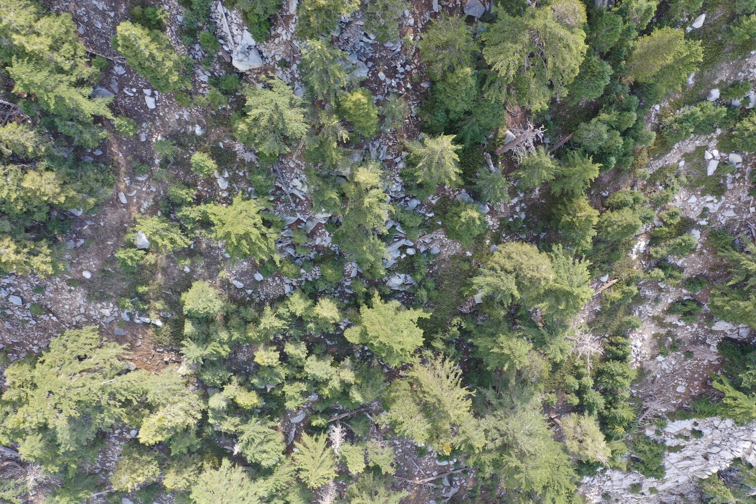
An Example of a Drone Image Searched by Volunteers
Morgan belongs to a small team of volunteer searchers led by Cathy Tarr to find David O’Sullivan, a 25-year-old backpacker who disappeared while trekking the Pacific Crest Trail in Southern California on April 7, 2017. Tarr’s volunteers are optimistic, hard-working, and dedicated individuals, all driven to help families of missing hikers. But they had spent two years searching over 5,000 aerial and satellite photographs for signs of O’Sullivan with no success. By December 2019, the process had begun to wear them down. And Morgan Clements was burned out on image searching.
“I was tired of looking at the same real estate over and over again,” he says, “with good but not great imagery.” Too many times he believed he’d found a bone, or a backpack, or a tent belonging to O’Sullivan only to be deflated once ground searchers hiked in to his coordinates and discovered the bone was a stick, the backpack was a rock, and the tent was a tarp abandoned by illegal marijuana cultivators.
Searching thousands of aerial images for evidence of a missing person is a tedious, headache-inducing process that frustrates Morgan so much his wife often hears him cursing at his computer. But Greg Nuckolls, founder of Western States Aerial Search, would say that a drone operator’s job isn’t any easier. To conduct a thorough search, drones must be programmed to fly a precise grid at the proper altitude while contending with variable terrain, thick vegetation, wind, fog, shadows, hauling heavy equipment to remote locations, and a short battery life. Another barrier to using drones to find the missing are regulations against flying unmanned aircraft within national parks and wilderness areas, the locations where most hikers disappear.
“It has been a tough journey. Waiting. Waiting. Waiting.”
— Stephanie Miller to The Palm Springs Desert Sun
On July 13, 2018, Paul Miller (51) told his wife he was going to take a short walk inside Joshua Tree National Park. He brought a hydration backpack and a camera bag with him, but left his cell phone in the hotel room. When he failed to return in time to for them to check out, his wife, Stephanie, reported him missing. That day, park rangers found Miller’s car at a trailhead. Hundreds of people, volunteers, professional searchers, six search dogs, and a helicopter crew spent 6,000 hours scouring the park for the Canadian. Seventeen months later, Miller was still missing and his family continued to suffer all the emotional and financial hardships that come with not knowing what happened to him.
In late 2019, with the blessing of Paul Miller’s family, the National Park Service made a rare exception to their no drone policy by issuing a permit to a nonprofit organization, Western States Aerial Search, allowing Greg Nuckolls to organize a drone search operation within the park. In one weekend, Nuckolls’s team captured 6,700 images of the ground in the area where Miller’s car was found. Weeks later, only 15 percent of these images had been searched.
An effective drone search requires much more than a guy with a drone. You need skilled drone operators with experience in search. You need a group of methodical image scanners. And you need people on the ground willing to hike off trail to rule out compelling items seen in the images. If your operation lacks one of these components, you are basically wasting your time. Although Cathy Tarr ensures she has people lined up for all three tasks for the aerial image searches she coordinates, Morgan worried. Would the Joshua Tree rangers and SAR volunteers have the same level of patience?
When Nuckolls requested help from Tarr’s group. Morgan verbalized these concerns via their Facebook group. Why commit to more mindless image scanning, he wondered, especially if there are no ground searchers willing to follow up on leads? Hesitant to commit so much time and effort to another missing hiker case, he reluctantly agreed to search a few random images from the thousands listed on a spreadsheet compiled by volunteer Gloria Boyd.
“Why commit to more mindless image scanning? Especially if there are no ground searchers willing to follow up on leads?”
Categorization can provide a strange comfort. In 2001, the tragedy of 9/11 triggered in Morgan a proclivity to map worldwide occurrences of terrorist activity. Over time, this peculiar hobby became a business. Today GlobalIncidentMap.com tracks many scary things—incidents of terrorism, disease outbreaks, human trafficking, and natural disasters. Impressed by his work, agencies within the military and the federal government have contracted Morgan’s services. His maps also have an aesthetic appeal. In 2008, the Museum of Modern Art (MOMA) in New York City displayed one in an exhibit. By then, Morgan’s hobby-turned-business had grown to the point he told a reporter that he sat in front of eight computers in his basement in Missouri and made maps for “people who don’t want to have their heads stuck in the sand.”
Morgan’s sense of humor runs cynical. But I suspect there’s an idealism lurking within. Today GlobalIncidentMap.com has moved out of Morgan’s basement and employs people all around the globe. Maybe just maybe, if Morgan’s company maps every incident of violence and horror in the world we can use that information to prevent it. This soft spot for humanity reveals itself most through Morgan’s pro bono efforts to help families of the missing.
The white thing was a thin stick with a knob at each end.
It looked like a bone.
Had they solved the case?
On 12/15/2019, Morgan had viewed over 100 images from the Paul Miller case when something in file PM_JTNP_P2_Z3_F2 (435) caught his attention. A stark white object lying on a patch of beige ground. Zooming in, the resolution faded as Morgan’s pulse quickened. The white thing was a thin stick with a knob at each end. It looked like a bone.
For validation, he sent a low resolution copy of PM_JTNP_P2_Z3_F2 (435) to two women. A nurse with training in human anatomy and an experienced image searcher. The nurse said, yes, the white thing appeared to be a bone, perhaps a femur, but the quality of the photograph was too poor for her to determine the species. Volunteer Sarah Francis pulled up drone photographs of the same area taken from different angles. She soon found more white things that looked like bones and located a round object that resembled a metal rim of a car wheel.
She sent a screenshot of of the “car wheel” to Morgan.
It’s not a wheel, Morgan told Sarah. It’s a hydration backpack propped up by the shoulder straps in a way that makes it look round.
Paul Miller had a hydration pack with him!
Had they solved the case?
Morgan and Sarah would have been more excited, but years of experience kept their hopes in check. The “hydration pack” that looked like a wheel could be a rock. The “bones” might belong to a cow.
Morgan posted the GPS location of the possible femur bone to the group’s spreadsheet then he and Sarah moved on to the next images on their spreadsheet.

A Needle in a Haystack
While searching for signs of a missing hiker’s blue backpack, human image searchers detected scores of blue items that later were confirmed by ground teams to be mylar balloons.
Days later, Morgan learned that Greg Nuckolls had immediately sent those GPS coordinates to the Joshua Tree park rangers who hiked in to the site the next day and found human remains. They also found a camera bag, bits of clothing, and a hydration backpack leaning up against a rock. The official determination was weeks away, but there was little doubt. The bone Morgan spotted in the aerial image belonged to Paul Miller.
While initial searchers on the ground had been within 30 meters of Miller’s body several times and missed him, a three-pronged approach—skilled drone pilots, disciplined image searchers, dedicated folks on the ground willing to check out leads—found Paul Miller 18 months after he disappeared.
After so much heart break and frustration, the years Morgan and others had spent searching aerial images for missing hikers finally helped one grieving family. Officials were unable to determine exact cause of death, but they believe it was unsuspicious and quick. Perhaps a heart attack or heat stroke. Morgan heard Miller’s family had received news of the discovery a few days before Christmas, and, although painfully bittersweet, the finding of Miller seemed like the best Christmas present ever.
Using software to search drone images for human remains may be faster, but Morgan believes humans do it better. On the O’Sullivan case, human eyes detected many items of interest a computer program missed. “The human brain is especially good at recognizing patterns of importance,” Morgan says. “Can you teach software to use intuition? Nope. Does software know to look specifically at the bottom of fall zones, or in shaded areas where a human might have sought shelter? Maybe someday, but we just aren’t there yet. (The software) will improve over time, but for now, if I am missing, I want humans looking for me.”
One case has been solved but there are more families still desperate for answers. So, after making a difference for Miller’s family, Morgan returned his computer screen. He may be there now, staring at his lap top. He clicks one image file of thousands, scrolls to the upper left corner and zooms in as close as he can. Then he begins to search, scanning from left to right, top to bottom, seeking the one clue that might end someone’s torment of not knowing.
© Andrea Lankford
“Miller’s sister, Dawne Robinson, told The Desert Sun that without the images from a drone – flown over the area in November by the Utah-based nonprofit organization, Western States Aerial Search – it’s hard to know how much longer the remains may have gone undiscovered”
